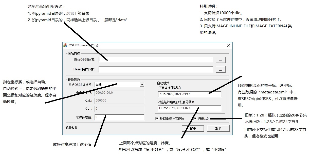
osgb转Cesium 3D tiles工具
目前Cesium不支持直接加载倾斜摄影的OSGB数据:
https://www.oschina.net/question/104733_2198017
但是可以通过转换将OSGB数据转换成Cesium可以加载的数据格式。
目前Cesium自己定义支持最好的格式应该是:3D Tiles。这种格式处于发展阶段还不够成熟。但是基于官方的一些Demo可以发现效果还是非常不错的。
3D Tiles在逻辑层,也就是JSON部分增加了FeatureTable和BatchTable,以及LOD(tileset)概念,并对应提供了header(二进制存储)。从数据规范角度来看,继承了glTF优秀的部分,同时考虑了倾斜,点云,后续也会支持OSM,从数据类型的支持上也比较到位。
3D Tiles = glTF + LOD
https://www.cnblogs.com/fuckgiser/p/6565957.html
在开发过程中,通过网上搜索发现了开发者分享出来的一些转换工具:
https://blog.csdn.net/qq_37796475/article/details/79221939
经过测试发现:
https://download.csdn.net/download/qq_37796475/10274378 这个工具的效果不错。
建议大家支持这个工具的分享作者,去CSDN下载,如果有需要,也可以留言邮箱,分享给您。
本文由 devhu 创作,采用 知识共享署名 3.0 中国大陆许可协议 进行许可。 可自由转载、引用,但需署名作者且注明文章出处。
这个有个数限制,不好用, 可以参照我的 github 项目: https://github.com/fanvanzh/3dtiles
目前我还没遇到个数限制哈,我大概800MB的数据,转换一点问题没有,不过也推荐这位朋友自己开源的项目: https://github.com/fanvanzh/3dtiles
另一种开源工具: 参考链接: https://github.com/fanvanzh/3dtiles
3dtiles
The fastest tools for 3dtiles convert in the world!
include these tools:
osgb => 3dtile , convert huge of osgb file to 3dtiles.
shapefile => 3dtile, convert shape file to 3dtiles.
fbx => 3dtile, convert fbx file to 3dtile, include auto_lod\texture convert etc..
3dtile 转换工具集。
世界上最快的 3dtiles 转换工具,极度节省你的处理时间。
命令行:
3dtile.exe [FLAGS] [OPTIONS] --format <osgb,shape> --input <FILE> --output <FILE>
示例:
3dtile.exe -f osgb -i E:\Data\倾斜摄影\hgc -o E:\Data\倾斜摄影\hgc_test

3dtile.exe -f osgb -i E:\Data\倾斜摄影\dayanta -o E:\Data\倾斜摄影\dayanta_test -c "{\"offset\": 0}"
参数说明:
-c, --config
     {

      "x": 120,

      "y": 30,

      "offset": 0 , // 模型最低面地面距离

      "max_lvl" : 20 // 处理切片模型到20级停止

     }
  -f, --format <osgb,shape>

  -i, --input <FILE>

  -o, --output <FILE>

  --height, 指定shapefile的高度字段
命令行参数详解:
-c 在命令行传入 json 配置的字符串, json 内容为选配,可部分实现。

-f 输入数据格式: osgb 为倾斜摄影格式数据。

-i 输入数据的目录,截止到 "\Data" 目录的上一级。

-o 输出目录。最终结果位于输出目录的 "\Data" 目录。

--height 高度字段。指定shapefile中的高度属性字段。
数据说明:
1、倾斜摄影数据:
倾斜摄影数据仅支持 smart3d 格式的 osgb 组织方式, 数据目录必须有一个 “Data” 目录的总入口, “Data” 目录同级放置一个 metadata.xml 文件用来记录模型的位置信息。
每个瓦片目录下,必须有个和目录名同名的 osgb 文件,否则无法识别根节点。
osgb 文件名中需要能识别出来是第几级,如 Tile_001_001_L8.osgb,程序能根据最后一个L识别出来第8级,否则程序无法辨认,产生的 geometricError 会有错误。
正确的目录结构如下:
--metadata.xml

--Data\Tile_000_000\Tile_000_000.osgb

--Data\Tile_000_000\Tile_000_000_L6.osgb
2、shapefile 数据:
目前仅支持 shapefile 的面数据,可用于建筑物轮廓批量生成 3dtile。
shapefile 中需要有字段来表示高度信息。
Hi! I want some help regarding 3Dtiles for display on cesium. I have a photogrammetry model that is prepared in Pix4d desktop application, I can have it in multiple formats including osgb, fbx, obj etc. I tried alot to create 3D tiles using various techniques, I am unable to do it sucessfully.
For "3dtile conversion toolset" I have to add metadata.xml along with osgb files, which i dont have, So i put an empty metadata.xml. It gives me the data copied in different folders along with json files tileset.json but when i run the code to display on cesium it gives me error and the data is not displayed. var tileset = new Cesium.Cesium3DTileset({ url: "mydata/tileset.json" }); viewer.scene.primitives.add(tileset);
viewer.zoomTo(tileset);
Please tell me where i am going wrong as soon as possible. I will be really very thankful.
@saadat2930 #7楼 hi, saadat2930, where are from?
- If you want to use the tool in this page, you should transfer your models to .osgb format.
- when you get osgb models, you can use the tool from url: https://download.csdn.net/download/qq_37796475/10274378
- pls click "立即下载"(download). if you don't have a vip account. you can mail me: tohujiulin@126.com, I will send u.
- just do follow: @devhu #1楼
@saadat2930 #7楼 I am sorry, my email can not reach gmail. Just try the attachment from the webdisk.
链接:https://pan.baidu.com/s/13aysULuiUx3GhzrWqCNWig 提取码:tkmn
link:https://pan.baidu.com/s/13aysULuiUx3GhzrWqCNWig key:tkmn
Cesium批量显示三维模型(gltf格式)和一些心得体会 https://blog.csdn.net/zxzfcsu/article/details/80957399
cesuim加载倾斜摄影OSGB三维数据完整过程(超详细) https://blog.csdn.net/qq_36377037/article/details/86591761
obj转gltf:


